Participant Information
Check-In
The UltraChallenge will take place rain or shine. All participants must check in at the farm between 3:45 AM and 4:45 AM on Saturday, August 25 where you will receive your race packet and ID tag. You may also check in on Friday evening between 6 PM and 8 PM. Please pin the tag on your right side at waist level so it can be scanned at each Checkpoint. You are responsible for ensuring your tag is properly scanned!
Starting
The shuttle bus will depart from the farm at 5:00 AM to take the individual participants and first leg relay team members to the trailhead where their tags will be scanned as before starting. All participants must take the shuttle bus or be dropped off; there is no parking at the start.
Aid Stations and Checkpoints
There are nine aid stations along the course providing water, sport drinks, soda pop, gels, and PB&J; sandwiches. Potatoes, candy such as M&Ms;, and other snacks will be available at some stations. Four of these stations are also relay transfer spots and checkpoints where your tag will be scanned and your time recorded. Except for the start, relay teams are responsible for their own transportation to and from each transfer spot. Below, bold indicates relay leg start/finish. Revised July 13 23:50.
| Aid Station | Cume miles | AS Delta miles | Relay Leg miles | Opening Time | Cutoff Time | Amenities | Latitude | Longitude |
|---|---|---|---|---|---|---|---|---|
| Start (map) | 0.0 | 6:30 AM | 6:30 AM | 41.11758 | -79.19591 | |||
| AS1 Zion Road (map) | 7.4 | 7.4 | 7:15 AM | toilet-portable | 41.05783 | -79.17215 | ||
| AS2 North Freedom (map) | 11.4 | 4.0 | 11.4 | 8:00 AM | 9:45 AM | toilet-portable | 41.02271 | -79.20762 |
| AS3 Route 839 (map) | 17.1 | 5.7 | 8:45 AM | 40.95757 | -79.22818 | |||
| AS4 Mahoning Dam (map) | 23.0 | 5.9 | 11.6 | 9:30 AM | 1:00 PM | toilet | 40.92378 | -79.28431 |
| AS5 Milton Church (map) | 29.0 | 6.0 | 10:15 AM | outhouse | 40.90879 | -79.21690 | ||
| AS6 Dayton-Smicksburg Road (map) | 34.0 | 5.0 | 11.0 | 11:00 AM | 4:15 PM | toilet-portable | 40.86959 | -79.19700 |
| AS7 Wilson Road (map) | 38.1 | 4.1 | 11:30 AM | toilet-portable | 40.82819 | -79.19676 | ||
| AS8 Rossmoyne Road (map) | 42.9 | 4.8 | 8.9 | 12:00 PM | 6:45 PM | toilet-portable | 40.79667 | -79.17319 |
| AS9 Griffith Road (map) | 46.3 | 3.4 | 12:30 PM | toilet-portable | 40.83928 | -79.15333 | ||
| Finish (map) | 50.0 | 3.7 | 7.1 | 1:00 PM | 8:30 PM | toilet-portable | 40.85428 | -79.19492 |
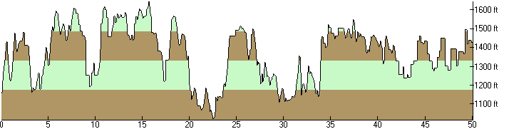
Elevation Profile of the 2018 UltraChallenge
Total Ascending: 7318 ft. Total Descending: 7056 ft.
Finish
All participants will finish back at the farm where food will be provided. A shower is also available for cleanup.
Awards
Awards will be issued to runners as their finishing position becomes official.
Course
The first relay leg (11.4 miles) is 34% trail, 2% dirt road, 64% paved road. The second leg (11.6 miles) is 4% trail, 13% dirt road, 83% paved road. The third leg (11.0 miles) is 89% trail, 5% dirt road, 6% paved road. The fourth leg (8.9 miles) is 6% trail, 79% dirt road, 15% paved road. The final leg (7.1 miles) is 0% trail, 87% dirt road, 13% paved road.
The trail surfaces are single-track or forest roads, which can include rocks, roots, sticks, branches, humps, and holes. The trail section on the third leg, between mile 23 and 29, is quite technical.
Beyond mile 41, the course will be marked exclusively with Baker Ultra signs and/or yellow arrows on the road (there are no blazes on this segment because it deviates from the Baker Trail).
Course Map
A map of the course is here (2.1MB PDF) (revised July 14 00:50). Right-click and choose Save As to download it to your local storage. It's vector format and thus can be printed on any size paper, the larger the better. Recent versions of Adobe Acrobat Reader offer a Poster feature that prints a single page across several sheets which increases legibility. Copies of this map will be available at check-in.
Drop Bags
You may leave bags or gear at the farm in the morning for pickup and use when you arrive there upon finishing. Also, you may have a bag delivered to any Checkpoint (AS 2, AS 4, AS 6, AS 8), and you may drop off gear, clothing, etc. at any aid station (plastic bags will be available). Everything will be brought back to the farm when the aid station closes. Be sure to label everything with your name and ID number.
Rules
Please adhere to these rules or risk disqualification:
- Runners must check-in at the start of the race, at each of the checkpoints, and the finish line.
- Runners must depart the checkpoint by the designated cutoff time. However, runners will be permitted to miss one of the first three cutoff times, provided it is by less than 30 minutes. Exceptions to this rule may be granted during the race and are solely at the discretion of the Race Director.
- Runners are not permitted to obtain any outside assistance. If a runner leaves the course for any reason (including getting lost), they must return to the course by their own power at the point they left it.
- At all times, only one member of each relay team may be on the course. Relay members must turn in their tag when they finish their last leg.
- Pacers are not permitted for relay runners.
- Pacers are permitted for individual runners beginning at AS5 Milton Church (mile 29). Pacers may not carry food, drink, or gear for the runner or provide any other assistance. Pacers are permitted to consume aid station food and drink. Runners are permitted one pacer at a time, and pacers must be at least 18.
- Support crews may meet their runner anywhere along the course, but must not impede traffic. Crews must not park or operate (a) on private property without permission from the property owner, nor (b) in an unsafe manner or location. Runners are responsible for the conduct of their support crew.
Transportation
There is no shuttle service to the aid stations! Relay teams must provide their own transportation. If you drop out at an aid station and cannot arrange your own ride, the volunteers will do their best to assist you in securing transportation. However, you will almost certainly be required to wait, perhaps for several hours, for someone to take you. If you drop out between aid stations, you will need to find transportation yourself.
ID Tags
If you drop out and don't make it to the finish, please give your ID tag to a Marshal. If you do not return your tag you will be charged a $5 replacement fee.
Advisories
- Hydrate, hydrate, hydrate. Drink lots of liquid in small amounts at a steady, frequent rate. You should be carrying at least two quarts.
- Water, sport drinks, and snacks will be available at each aid station.
- Wear a hat and use a high-SPF sunblock. You'll be outside all day.
- Watch the weather forecast closely to know what gear to bring; the UltraChallenge will happen rain or shine.
- Stay on the trail!
- Backtrack to find the last trail blaze and reassess your direction if you haven't seen a blaze in a hundred yards or so, as you may have missed a turn.
- Respect private property! Much of the Baker Trail crosses privately owned land and the owners graciously allow us there; do not impose upon any landowner you may encounter.
- Clean up any trash you bring and any you encounter along the way. There are trash receptacles at each checkpoint.
- Stop if you feel sick!
- Check in at each checkpoint. This is how we keep track of you! You must have a time recorded at the start and every checkpoint or your finish time will be disqualified.
Volunteers
We'll need quite a few volunteers to help us stage the UltraChallenge. Please cajole and/or coerce your friends, relatives and co-workers into helping! Review the Volunteer Roles and Responsibilities and mark the meeting date on your calendar!