Participant Information
Check-In
The UltraChallenge will take place rain or shine. All participants must check in at the farm between 4 AM and 5:30 AM on Saturday, August 26 where you will receive your race packet and ID tag. You may also check in on Friday evening between 6 PM and 8 PM. Please pin the tag on your right side at waist level so it can be scanned at each Checkpoint. You are responsible for ensuring your tag is properly scanned!
Starting
The shuttle bus will depart from the farm at 5:40 AM to take the individual participants and first leg relay team members to the trailhead where their tags will be scanned as they start out, as early as 6:05 AM if there is sufficient light. All participants must take the shuttle bus; there is no parking at the trailhead.
Aid Stations and Checkpoints
There are 11 aid stations along the course providing water, sport drinks, Coke, gels, sandwiches, and bagels. Candy such as M&Ms; and other snacks will be available at some stations. Four of these stations are also relay transfer spots and checkpoints where your tag will be scanned and your time recorded. Except for the start, relay teams are responsible for their own transportation to and from each transfer spot. Each Checkpoint has a designated cutoff time; participants must depart the checkpoint by the appointed time or they will be pulled out.
| Aid Station | Cume Miles | AS Delta Miles | Relay Leg Miles | Opening Time | Cutoff Time |
|---|---|---|---|---|---|
| Start: Route 28 (map) | 0.0 | 6:00 AM | |||
| AS1: Zion Road (map) | 7.9 | 7.9 | 7:15 AM | ||
| AS2/CP: North Freedom (map) | 12.0 | 4.1 | 12.0 | 7:45 AM | 10:00 AM |
| AS3: Mount Tabor (map) | 15.7 | 3.7 | 8:00 AM | ||
| AS4: Route 839 (map) | 18.1 | 2.4 | 8:15 AM | ||
| AS5/CP: Eddyville (map) | 22.0 | 3.9 | 10.0 | 8:45 AM | 12:45 PM |
| AS6: Crossroads Road (map) | 25.4 | 3.4 | 9:15 AM | ||
| AS7/CP: Milton (map) | 29.0 | 3.6 | 7.0 | 9:30 AM | 2:45 PM |
| AS8: Dayton-Smicksburg Road (map) | 34.1 | 5.1 | 10:15 AM | ||
| AS9/CP: Sinktown Road (map) | 39.8 | 5.7 | 10.8 | 10:45 AM | 5:45 PM |
| AS10: Plumville (map) | 42.3 | 2.5 | 11:00 AM | ||
| AS11: Wells Road (map) | 45.7 | 3.4 | 11:30 AM | ||
| Finish: Smicksburg farm (map) | 50.1 | 4.4 | 10.3 | 12:00 AM | 8:30 PM |
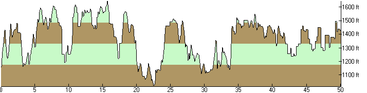 |
| Elevation Profile of the 2006 UltraChallenge Total Ascending: 7318 ft. Total Descending: 7056 ft. |
Finish
All participants will finish back at the farm where food will be provided. Showers are also available for cleanup.
Awards
The awards ceremony will be held at the farm at 4:30 PM.
Course Map
A map of the course is here (1.1MB JPEG).
Drop Bags
You may leave bags or gear at the farm in the morning for pickup and use when you arrive there upon finishing. Also, you may have a bag delivered to any Checkpoint (AS 2, AS 5, AS 7, AS 9), and you may drop off gear, clothing, etc. at any aid station (plastic bags will be available). Everything will be brought back to the farm when the aid station closes. Be sure to label everything with your name and ID number.
Transportation
There is no shuttle service to the Checkpoints! Relay teams must provide their own transportation. If you drop out at an aid station and cannot arrange your own ride, the volunteers will do their best to assist you in securing transportation. However, you will almost certainly be required to wait, perhaps for several hours, for someone to take you. If you drop out between aid stations, you will need to find transportation yourself.
ID Tags
If you drop out and don't make it to the finish, please give your ID tag to a Marshal. If you do not return your tag you will be charged a $5 replacement fee.
Advisories
- Hydrate, hydrate, hydrate. Drink lots of liquid in small amounts at a steady, frequent rate. You should be carrying at least two quarts.
- Water and snacks will be available at each aid station, every 3-8 miles.
- Wear a hat and use a high-SPF sunblock. You'll be outside all day.
- Watch the weather forecast closely to know what gear to bring; the UltraChallenge will happen rain or shine.
- Stay on the trail. Shortcuts may not be fair to other participants and can upset landowners.
- Backtrack to find the last trail blaze and reassess your direction if you haven't seen a blaze in a hundred yards or so, as you may have missed a turn.
- Resist forging ahead or spending time trying to "hook up" with the trail if you lose it; this rarely works to your benefit.
- Respect private property! Much of the Baker Trail crosses privately owned land and the owners graciously allow us there; do not impose upon any landowner you may encounter.
- Clean up any trash you bring and any you encounter along the way. There are trash receptacles at each checkpoint.
- Stop if you feel sick!
- Check in at each checkpoint. This is how we keep track of you! You must have a time recorded at the start and every checkpoint or your finish time will be disqualified.
Volunteers
We'll need quite a few volunteers to help us stage the UltraChallenge. Please cajole and/or coerce your friends, relatives and co-workers into helping! Check out the Volunteers page for details.