| Having trouble viewing this email? View it in your browser | | | |  | Preserving and Promoting Community Trails
in Western Pennsylvania | |
| | |
| | | 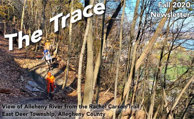   |  |  | Grand Views Coming to the Rachel Carson Trail By John Stephen An unpleasant and dangerous segment of the Rachel Carson Trail has been transformed from a hazard to a highlight thanks to our largest property acquisitions to date. Over the past year, the Conservancy has purchased 17 acres at the corner of Murray Hill and Riddle Run Road in Frazer Township and 43 acres to the north of the Murray Hill Estates community in East Deer Township. The two purchases are supported by grants from Pennsylvania’s Community Conservation Partnership Program and the Allegheny Regional Asset District. But the opportunity to even consider the acquisitions came from the contributions of members and hikers enjoying the trail and the annual Rachel Carson Trail Challenge. Since late 2017, the Conservancy’s Safer Trails committee has been researching routes and reaching out to property owners to move the trail off roads. Along with the aforementioned acquisitions, four generous private landowners on the west side of Riddle Run Road consented to hosting the trail on their properties. Together, this has completely changed the character of the section between Springdale and Creighton. The trail is now almost entirely off-road, making it safer, sylvan, and serene. And soon, the trail will no longer pass through the backyards and patios of Murray Hill Estates residents and will instead feature grand views up and down the Allegheny River. Trail stewards and volunteers have been busy building the new trail all summer long. An open house will be held in early spring to celebrate the effort and energy of our volunteers, thank landowners, and introduce the trail to our neighbors. Stay tuned to the RCTC social media and website for details. |
 Harmony Trail Extends North to Bradford Woods By John Stephen The Conservancy has taken some initial steps toward the long term vision of blazing a hiking trail from Route 910 in Pine Township to McConnells Mills State Park and the North Country Trail. The first successes are a result of the outreach work of the Conservancy’s Harmony Trail committee and partnerships with the municipalities promoting the Commodore Perry Trail Network. A new sidewalk along Brennan Road is scheduled to be constructed over the winter. Not everyone will see this as the start of a path to Slippery Rock Creek…but for members of the Conservancy and hikers of western Pennsylvania it will be seen a crucial baby step toward closing the largest gap of the Rachel Carson Loop. The Harmony Trail grows as we stitch together the remnants of the former Harmony Short-Line railway right-of-way with walkways of new commercial and residential developments, long term municipal trail plans, and innovative trail blazing partnerships facilitated by the Conservancy. This first extension is an example. The trail will cross Route 910 (thanks to Pine Township) and use the walkways of the new Wexford Station Development until it reaches Brennan Road in Pine Township. A little north, the Harmony right-of-way is owned by Penn Power. At this point the Bradford Woods Conservancy has agreed to partner with us to blaze the trail beneath the power lines and into and through the tree-lined and traffic-calmed neighborhood. Forest Road in Bradford Woods Borough is already enjoyed by walkers in all seasons. The two non-profit conservancies will work on a complementary and subtle blazing and signage system that both highlights the role that the Harmony Short-Line played in the Borough’s founding and recognizes the role the Harmony Trail will play in the community’s future quality. The vision of extending a walking route toward the North Country Trail will require a series of sections, each with its own character, challenges and opportunities, to link through Marshall, Cranberry, and Jackson Townships; Zelienople and Harmony Boroughs; and Beaver and Lawrence Counties. Over the winter the Many Trails, One Community page of our website will be updated with descriptions of the different sections and status of efforts to stitch the vision together. The next update will feature the work of volunteers growing and maintaining the Connoquenessing Valley Heritage Trail system around Zelienople and Harmony. |  |  |
") | | G.O.A.T. (Goats on a Trail) By Bob Mulshine Goats! What a great distraction in this age of pandemic. Twelve little goats and their donkey protector were on display for our entertainment as they ate away problem plants beside the Harmony Trail for ten days in September. Many people learned we had goats along the trail through social media and used the trail to come see them. We had just added more surfaced trail south toward Richard Road making the trail almost one mile long. We wanted people to come and enjoy it, and thought goats would be a unique enticement, especially for families. Although the goats turned out to be a bleating success in bringing people and attention to the trail, we had rented the herd to address our knotweed problem. We began working this knotweed problem about four years ago, but knotweed is really hard to get rid of. It grows very quickly and can get to eight feet tall in one season. It dies back to the ground over the winter, and reproduces from seeds and from its roots making it fast spreading. We looked for a way to kill it without using chemicals. We settled on letting it do its spring growth spurt of 3 or 4 feet before cutting it back to the ground in early to mid-June. This is supposed to let the plant use up all of the food stores in its roots and then interfere with its creating more food stores by eliminating the green leaves. It would eventually grow back to 3 to 4 feet high. We would cut it to the ground again when it started to flower in September. This would help keep it from growing new plants through seed as well as reducing the amount of food stores it could make. We were told that by harassing it like this for a few years we could weaken it which could keep it from spreading and hopefully reduce it over time. The goats can’t eat it back any more effectively than we can cut it, so their work replaces our second cut back of the season. Their work was part of the process not a solution. |
Multi-Modal Microadventures on the Rachel Carson Trail By David "Thatch" Fockler As a thruhiker, I always appreciate a grand adventure that takes me as far away from home as possible. Seeking to replicate that big experience on a smaller scale here at home, I've developed an approach that maximizes the adventure factor. Avoiding the constraints and complications of the typical out-and-back or car shuttle trip, I've learned to incorporate multi-modal travel to unencumber myself and open up the possibilities. I'll hop a bus to the trail, then hike or run to the next transit stop or just hail a ride (Lyft, Uber) to get home. I can go however far I want, and I get a taste of that thruhiker freedom. Adding different modes of travel increases the psychological distance, amplifying a small adventure into something resembling an out-of-state, out-of-the-comfort-zone learning experience. On a deeper level, multi-modal travel puts me into contact with people and communities along the trail corridor, fostering a deeper understanding of our region. Pittsburgh is extremely fortunate to have a transit-accessible trail of effectively unlimited length (RCT connects to the Baker Trail and North Country Trail, offering 5,000 miles of adventure between Vermont and North Dakota). Here are a few shorter transit-assisted trips I recommend for the RCT: - The eastern half of the RCT, from Harrison Hills Park to Springdale, is served by Port Authority 1 and P1 buses. I'll typically start at Bull Creek Rd in Tarentum and hike to Springdale, ending with a beer at the Leaning Cask Brewery.
- North Park is accessible via the 12 bus terminating at the McCandless Park and Ride. It's a one-mile walk or bicycle ride into the park, and three miles to Over The Bar Bicycle Cafe, where I can reward myself for a trip well done. All Port Authority buses are equipped with bike racks.
- Hartwood Acres Park is accessible via the 91 bus to Fox Chapel Rd. I'll load up on caffeine and calories at Getgo and take the Old Squaw Trail to the new Beechwood Connector and on to the RCT, turning either east or west to finish at either of the above locations.
Even if you'll be driving a car to the trail, I'd still encourage you to spice up your adventure by taking a bus or rideshare back to your car. Ride-hailing offers novel logistical solutions and affords an opportunity to meet the drivers, many of whom are from diverse cultural backgrounds. These exchanges transcend our siloed cultural bubbles and can be eye-opening and fulfilling. Thruhiking the Appalachian Trail taught me that the trip can be bigger than just the trail. So, go ahead and spice up your hike with some travel; turn that dayhike into a microadventure! | |  |
 | | Plan Your Hike By Amy Nelson For many of us, tackling the Rachel Carson Trail is daunting. Without the support offered through training hikes or the kind of assistance provided during events like the annual Rachel Carson Trail Challenge, many would understandably opt for taking a pass on a long hike conducted in isolation. Just figuring out where to park along the 45-mile expanse can be overwhelming. To help with that, the RCTC created an online tool that simplifies the planning efforts for those tackling an excursion on our trails. The Plan a Hike tool empowers individuals to take on the trails with a level of confidence typically reserved for veteran hikers who have already logged countless miles. The tool, which is found on the Rachel Carson Trail page of our website, is fully integrated with the adjacent map on the page. There are two different ways to use the tool. The first and more popular option is to plan your excursion using the drop-down menu which alphabetically lists parking locations. This option includes every possible parking spot and every conceivable ending location. You will find more than one hundred segments from which to choose! The tool’s second option offers similar prospective hikes categorized by distance. In either scenario, your chosen start and end points come with map links to Google where you can get driving directions. The Plan a Hike tool is also available on the Baker Trail page and allows hikers (and runners) to plan excursions on our 134-mile path. While the tool can assist in planning your hikes, once your feet hit the trail, the rest is up to you! Follow the yellow blazes. Good luck and happy trails! |
OptOutside after Thanksgiving By Amy Nelson For the fifth consecutive year, the RCTC is teaming up with North Park Trail Runners (NPTR) to host the annual #OptOutside event. This free, family-friendly, socially-distanced trail run will take place the day after Thanksgiving. The goal is to get outside on Black Friday and avoid the frenzy of shopping and consumerism. This year’s event will take place on the trails of Riverview Park, located in the city of Pittsburgh’s North Side. Historically, the event is held on the Rachel Carson Trail in Hampton Township. The Diversity, Equity and Inclusion committees from both the RCTC and NPTR decided to move the event to a city park with the hope that the location change would allow for greater accessibility for a broader range of families. We will meet at the Riverview Park entrance, adjacent to the Allegheny Observatory. From there, we’ll head into the woods and hike (or run!) a 1-mile loop. Older kids are encouraged to tackle the loop twice (double the fun). The trail will be well marked. All ages are welcome, but a word of caution: the trail is not stroller friendly. Participants with very young children should consider some type of baby carrier. For event details and registration, please visit the #OptOutside Event page. While this event is free, we encourage you to register to help us plan the day. | |  |
 | | How I Got Involved By Levi Wilson, Board Member I am a little fuzzy regarding the conversation with a coworker in 2018, but I'm sure it had to do with one of my many camping trips and talking about all the hiking trails I have been on. He told me he had been hiking with his buddy on the Rachel Carson Trail doing the training hikes to get ready for the Challenge. It really piqued my interest and that day I searched for the RCT Challenge online. After looking at pictures from past years, and finding out that the trail was right in my back yard, I wanted to try it. Unfortunately, I was too late for the 2018 challenge, but I figured it would give me a year to train for 2019. I started my training by walking around my work parking lot and walking around my town. Then when 2019 came, I ended up doing my first event training hike on the RCT. I signed up for the Half Challenge to see if I could do it. After doing almost all of the training hikes, and some of orientation hikes, I was hooked and got a real taste of what the Rachel Carson Trail was. I started very slow, with many stops while going up many hills. I remember one time a lady passed by me on Log Cabin Hill as I was out of breath and said to me, "at least you're breathing." With each time out on the RCT I noticed I got better and better. Soon, I was able to carry a conversation while hiking up Log Cabin Hill, without stopping or getting out of breath. The number one thing I enjoyed was all the people I was meeting at each hike. On Challenge day, with both of my IT bands going out on me, I had to end the Challenge by walking sideways down the hills. But I crossed the finish line!!! I kept an eye on the event email which I signed up for. I went to a fall hiking event, one of the Barb Peterson Orientation hikes, and met Bob Reiland, RCTC Board President. We ended up talking and he told me about a Saturday hiking group he was in. Soon after, I joined and ended up seeing a few of the hikers that I already met doing the training hikes. Shortly after that, I received an email from RCT about reroute work on Ridge Road. I decided to show up to see how trails were made. I met Mark Eyerman and Steve Mentzer. I was hooked. Mark made it fun, safe, and gave a lot of knowledge on making trails. I showed up for all but one or two Ridge reroute work days, and got to know Mark really well along with a few other people who were hooked like me. And I kept coming back to help. Shortly after getting all the emails from Donna Stolz about volunteer opportunities, I got an email about a Trail Steward slot opening. I signed up to take care of the trail from Agan Park to Crawford Run Road which included Riddle Run Road, so I also volunteered to help on the Riddle Run reroute work days. Everything fell together when I learned there was an opening to be on the RCTC Board for the trail I had fallen in love with and enjoy hiking on, expanding, and doing upkeep on. That's my story and if you see me out on the RCT, feel free to say hi and let me know what you think about our trails!!! |
| |
 | | |
| |
|

")


